Mapping Baffin Island vegetation in the past, present and future from tree line to polar desert
The goal of the vegetation portion of the PACEMAP project is to describe and map contemporary vegetation around the targeted lakes spanning a bioclimate gradient from tree line (northern Quebec; 58.1 °N) to polar desert (northernmost Baffin Island 73.7 °N). This information will be used to:
a) analyze the relationship between current climate variables (summer temperature and moisture balance) and vegetation,
b) reconstruct past vegetation using the relationship between current vegetation and sediment deposition, and past sediment cores,
c) describe vegetation colonization and succession on Baffin Island since the last glacial maximum, and
d) predict future vegetation based on IPCC climate models and vegetation as determined from sediment records from past warmer time periods (last interglacial).
2019 AGU Posters
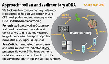
Assessing Change in Summer Arctic Moisture Source and Aridity over the Past 7,000 Years Using Leaf Wax δ^2H in Baffin Island Lake Sediment (Gorbey et al. 2019)
Get In Touch
The Alaska Geobotany Center is located on the West Ridge of the University of Alaska Fairbanks campus. Our office is located in room 252, on the second floor of the Arctic Health Research Building.