NICOP Dalton Highway Field Trip
This field trip left Fairbanks early on Monday morning, June 23, and returned on June 27. We rode a Holland America bus all the way to Deadhorse, Alaska, over the course of five days, and were treated to an in-depth view of the landscapes and research along one of the most remote and scenic highways in North America.
Moving quickly through the interior forests, we made several stops, including an experimental trenching site at Washington Creek, the Yukon River, Finger Mountain (site of large fires in 2004), and spent the night at Coldfoot Camp.
On the second day, our stops included Sukakpak Mountain (large ice mounds and fens), treeline, and the Chandalar Shelf (low alpine landscapes). We stopped several times as we drove up and over Atigun Pass, and Dr. Thomas Hamilton spoke about the glaciated landscapes of the Brooks Range. Before reaching Toolik Field Station, we stopped at a huge aufeis field at Galbraith Lake.
On the third day, scientists at the Toolik Field Station and Imnavait Creek provided an overview of the Arctic Long-Term Ecology Research (LTER) and several other ongoing projects.
On the fourth day, we visited the northern foothills and the interior part of the Arctic Coastal Plain, stopping at research sites at Happy Valley (central foothills of the Brooks Range), Sagwon (northern edge of the foothills), and Franklin Bluffs (central Arctic Coastal Plain) with in-depth presentations of permafrost and soil research by Dr. Chien-Lu Ping and other arctic scientists.
We overnighted at Deadhorse and spent the fifth day on a tour of the Prudhoe Bay oil field conducted by Dr. Bill Streever and industry personnel. The field trip ended with a charter flight back to Fairbanks.
The major themes of the tour included permafrost and ecosystem variation along the Arctic climate gradient, biocomplexity of patterned ground, and Pleistocene glaciations of Northern Alaska.
Publications and handouts from the trip
Walker, D.A., Hamilton, T.D., Ping, C.L., Daanen, R.P., and Streever, W.W., 2009, Dalton Highway Field Trip Guide for the Ninth International Conference on Permafrost, 104 p.
Download PDF (8.4 MB; from Alaska Geobotany Center)
Download PDF (8.4 MB, from DGGS website)
Purchase a print copy: Alaska Division of Geological & Geophysical Surveys, Guidebook 9 (select link "Ordering Info" in upper right corner of page).
Brown, Jerry, and Kreig, R.A., 1983, Guidebook to permafrost and related features along the Elliott and Dalton Highways, Fox to Prudhoe Bay, Alaska, 230 p.
Download PDF (21.0 M; from DGGS website).
Purchase a print copy: Alaska Division of Geological & Geophysical Surveys, Guidebook 4 (select link "Ordering Info" in upper right corner of page).
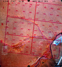
Aerial photos of Happy Valley watertracks (select image for printable version).
Field trip blog
NICOP Dalton Highway Field Trip
Photos
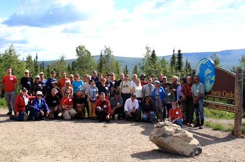
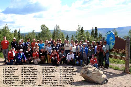
Group Photo
Photo with names (PDF, 45.5 MB)
Photo without names (PDF, 21.2 MB)
This photo links to a .pdf file suitable for printing (11.9 in x 7.9 in; 30.2 cm x 20.1 cm; 13.34 mb). Let me know if you're incorrectly identified.
Same photo without the names that links to a .pdf file suitable for printing.