
Circumpolar Arctic Vegetation Mapping Project
[an error occurred while processing this directive]About the Project
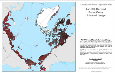
The Circumpolar Arctic Vegetation Map (CAVM) project was an international effort to map the vegetation and associated characteristics of the circumpolar region, using a false color infrared image created from AVHRR satellite data as the base map. A composite image was created by selecting pixels of maximum reflectance from 1993 and 1995 data. Mapping efforts in Canada, Norway, Greenland, Russia, Iceland and the United States used uniform methods to integrate information on bioclimatic zones, bedrock, surficial geology, acidity of parent material, soils, hydrology, remotely-sensed vegetation classification, Normalized Difference of Vegetation Index (NDVI), previous vegetation studies, and the regional expertise of the mapping scientists.
Maps of vegetation complexes and plant biomass are examples of the derived products that can be created from the CAVM database, linking biophysical attributes with the dominant vegetation type. Lookup tables created in ARCINFO link the biophysial attributes and allow the mapping and determination of the areal extent of each attribute category.
The CAVM shows the types of vegetation that occur across the Arctic, between the ice-covered Arctic Ocean to the north and the northern limit of forests to the south. Environmental and climatic conditions are extreme, with a short growing season and low summer temperatures. The region support plants such as dwarf shrubs, herbs, lichens and mosses, which grow close to the ground. As one moves southward (outward from map's center in all directions), the amount of warmth available for plant growth increases considerably, allowing the size, abundance, and variety of plants to increase as well. Climate and other environmental controls, such as landscape, topography, soil chemistry, soil moisture, and the available plants that historically colonized an area, also influence the distribution of plant communities.
See the Toolik-Arctic Geobotanical Atlas for more information about CAVM map themes, map data, and images.